Utility Design and Drafting Services

Precision Utility Drafting for Safer, Smarter Projects

At Gsource, we transform your field data, utility records, as-built information, and site measurements into accurate, compliance-ready utility maps and design drafts that support safe construction, efficient planning, and smooth infrastructure development. With 16+ years of global AEC experience, a 350+ multidisciplinary team, ISO-certified processes, and a 99% client satisfaction rate, we deliver end-to-end utility design and mapping support globally that ensures precision, clarity, and full adherence to utility and municipal standards.

Write to us
Precision Utility Drafting for Safer, Smarter Projects

What Our Clients Achieve

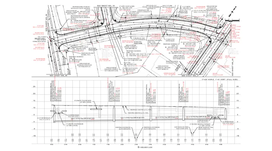
30% faster delivery of utility maps, linework, and design-ready CAD files

variance across utility alignments

<2% variance across utility alignments, depths, easements, and right-of-way details

24/7 collaboration with expert GIS, LiDAR, and photogrammetry teams

24/7 collaboration with expert utility drafters and engineering specialists

compliance with municipal

100% compliance with municipal, DOT, utility provider, and safety regulations

cost savings through precise drafting and reduced revision cycles

Up to 35% cost savings through accurate documentation, reduced clashes, and fewer redesigns

Associated With

Show More

Our Utility Design and Drafting Services

Underground Utilities

Underground Utilities

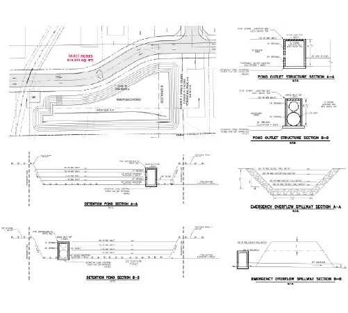
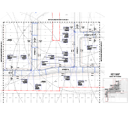
Detailed mapping of underground utility lines to ensure safe excavation, accurate planning, and conflict-free construction.

Designing Water Storage Networks

Designing Water Storage Networks

Comprehensive drafting of water storage layouts, connections, and distribution systems for efficient, reliable infrastructure planning.

Intricate Utility Line Drawings

Intricate Utility Line Drawings

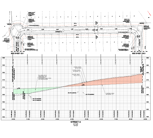
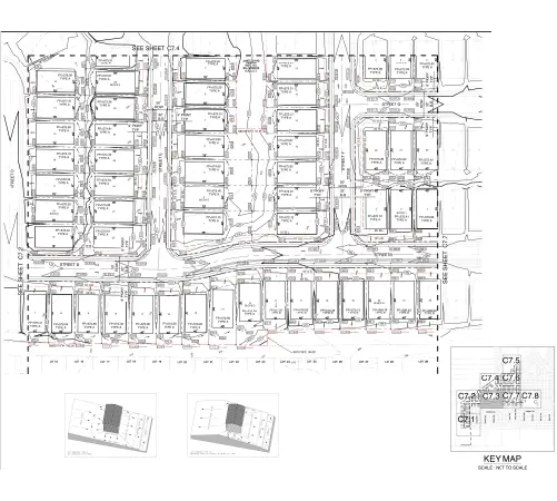
Precise CAD drawings of utility routes, alignments, and connections supporting seamless coordination and construction accuracy.

Intricate 3D Models

Intricate 3D Models

High-detail 3D utility models visualizing underground and above-ground systems for improved analysis, planning, and clash detection.

Plotting Utility Pole Locations

Plotting Utility Pole Locations

Accurate placement and drafting of utility pole positions for optimized routing, design efficiency, and field implementation.

Electric and Gas Infrastructure

Electric and Gas Infrastructure

Comprehensive drafting of electric and gas utility layouts, ensuring safe design, regulatory compliance, and uninterrupted distribution.

Wastewater Treatment Plans

Wastewater Treatment Plans

Detailed drafting of wastewater pipelines, treatment components, and facility layouts for compliant and efficient system planning.

Strategic Engagement Models

Get tailored solutions to fit your project’s scale and complexity

Project-Based

Clearly defined deliverables & fixed-scope milestones.

  • Scope: Clearly defined deliverables
  • Timeline: Fixed timeline
  • Pricing: Per project

Retainer / FTE

Ongoing technical support & on-demand expertise.

  • Scope: Prepaid monthly
  • Priority: Faster turnaround
  • Pricing: Prepaid blocks with expiry metrics

Dedicated Team (POD)

High-volume multi-disciplinary, & long-term integration.

  • Scope: Full-time, client-aligned team
  • Priority: Consistency & deep project familiarity
  • Pricing: Fixed monthly per resource

Hybrid Model

Adaptive workflows & complex, evolving project requirements.

  • Scope: Core team + on-demand support
  • Priority: Flexible scaling & balanced turnaround
  • Pricing: Monthly base + variable billing

What Do Our Clients Say?

Gsource’s utility mapping support helped us finish a full subdivision project with zero field conflicts. Their accuracy saved us weeks in redesign.

Mark Peterson

Utility Project Manager

Their 3D utility models significantly improved our clash detection process. Our team could coordinate designs faster and more confidently.

Elena Rodriguez

Infrastructure Design Lead

We rely on Gsource for all our utility line drafting- they’re consistent, detail-oriented, and always on schedule.

Chris Bennett

Senior Civil Designer

Thanks to Gsource’s precise pole location mapping, our electrical network upgrade went smoother than expected. Excellent turnaround time.

Jasmine Howard

Electrical Planning Supervisor

Their drafting team delivered accurate as-built utility documentation across multiple sites with impressive speed and clarity.

Derrick Williams

Construction Documentation Manager

Our Projects

Efficient Stormwater Design

Stormwater Management for a Multi-Phase Project

A 143-acre residential development in Texas required a detailed Stormwater plan and profile to manage runoff efficiently across a multi-phase site. With varying terrain and expanding infrastructure, the client needed a solution that ensured proper drainage, minimized flooding risks, and complied with county regulations. The objective was to design a coordinated Stormwater system that could function effectively across all phases while integrating seamlessly with the overall site development.

Services Offered:

Land Development

Grading Design

Pipe Network Design

Utility Design & Coordination

Explore Project
Optimizing Stormwater Management Drainage Area Mapping

Optimizing Stormwater Management Drainage Area Mapping

Having a well-defined drainage area map is important for managing Stormwater in large developments. For this area, the goal was to identify natural drainage patterns and divide the site into logical catchment zones. The project needed to align topographic data with proposed development plans to ensure proper runoff and infrastructure planning.

Services Offered:

Drainage Area Identification

Stormwater Flow Direction

Watershed Analysis and Mapping

Explore Project
Efficient Stormwater Design

Stormwater Management for a Multi-Phase Project

A 143-acre residential development in Texas required a detailed Stormwater plan and profile to manage runoff efficiently across a multi-phase site. With varying terrain and expanding infrastructure, the client needed a solution that ensured proper drainage, minimized flooding risks, and complied with county regulations. The objective was to design a coordinated Stormwater system that could function effectively across all phases while integrating seamlessly with the overall site development.

Services Offered:

Land Development

Grading Design

Pipe Network Design

Utility Design & Coordination

Explore Project
Paving Plan & Profile Design for Residential Development

Paving Plan & Profile Design for Residential Development

Paving plan and profile design are important components of land development that ensure safe, efficient, and durable road infrastructure. This project designs a paving system for large-scale mixed-use development. The goal was to create a well-structured road network that integrates seamlessly with site grading, drainage systems, and utility layouts while meeting regulatory standards and ensuring long-term performance.

Services Offered:

Plan and Profile Design for Internal Road Network

Grading

Explore Project

Smart Grading Solution for Large-Scale Site Development

Grading plays an important role in transforming raw land into a build-ready site. For a large-scale 130-acre development, a grading plan helps to balance earthwork, maintain natural terrain, and ensure compliance with local regulations.

Services Offered:

Grading Plan Design

Slope Stabilization

Drainage Coordination

Explore Project
Smart Utility Planning for 143-Acre Development

Smart Utility Planning for 143-Acre Development

A large-scale residential development in Texas required detailed utility planning to support a 143-acre, three-phase project. The client needed accurate and code-compliant water and sewer drawings that could seamlessly integrate with the overall site development plan. With multiple inputs and strict county regulations, the focus was on delivering coordinated, construction-ready drawings within tight timelines.

Services Offered:

Water Supply Plan

Sanitary Sewer Plan & Profile

Explore Project

Struggling With Complex Utility Data?

Let our team turn it into clear, build-ready plans.

Let our team turn it into clear, build-ready plans.

Why Choose Gsource for Utility Design and Drafting Services

Rigorous Quality Assurance

Rigorous Quality Assurance

Multi-level QC for error-free as-built drawings.

Expert Team members

Expert Teams

Skilled professionals with deep industry experience.

Strict Data Security and Confidentiality

Strict Data Security

Confidentiality maintained with strict protocols.

Reliable, Predictable Turnaround

Faster Turnaround

Precision and accuracy delivered on tight schedules.

Cost-Effective Production Model

Competitive Pricing

High-quality services without breaking your budget.

Standards-Driven Processes

Standards-Driven Workflow

Aligned with ISO 9001 and ISO 27001 for consistent quality.

Dedicated Project Coordination

Dedicated Support

Single point of contact with real-time updates throughout the project.

Post-Delivery Assistance and Documentation

Post-Delivery Assistance and Documentation

Clean, organized files with quick help for any updates after delivery.

Book a free consultation

Get expert support to streamline your next project.

Free Initial Consultation

Free Initial Consultation - No Commitment Required

Secure and Confidential Project Information

Secure and Confidential Project Information

Years of AEC Expertise

16+ Years of AEC Expertise

Drawing Deliverables Daily

300+ Drawing Deliverables Daily

Industry Standards Compliance Guaranteed

Industry Standards Compliance Guaranteed

Upload a File (Optional)

File(s) size limit is 20MB.

Got a bigger file? Just drop a shareable link in the description instead.

FAQs

To begin the utility design process, Gsource requires site plans, existing infrastructure layouts, topographical details, road alignments, current and proposed utility information, basic survey data, and any project-specific standards or client instructions.

Project timelines and costs depend on factors such as site size, complexity, input data quality, number of utilities involved, and required deliverables. Gsource discusses timelines and budgets upfront to ensure complete transparency and alignment with client expectations.

Yes. Gsource can review, update, or enhance existing utility plans, incorporate field changes, integrate new utilities, and deliver revised CAD drawings or 3D models as per project requirements.

Yes. Gsource offers detailed 3D utility modeling for water, sewer, gas, electric, telecom, and stormwater systems to support clash detection, design validation, and construction planning.

Absolutely. We convert survey data, GIS layers, LiDAR/point clouds, and as-built information into accurate utility maps, CAD drawings, and 3D models tailored to your project standards.

We work with AutoCAD, Civil 3D, MicroStation, ArcGIS, Revit, and other industry-leading platforms to deliver precise utility designs and mapping documentation.

Yes. Gsource adheres to municipal guidelines, DOT standards, utility provider specifications, safety regulations, and client-specific CAD/BIM standards to ensure full compliance.

Yes. Gsource specializes in utility design and mapping for highways, master plans, commercial developments, industrial facilities, and urban infrastructure networks.

Yes. We identify potential clashes between proposed and existing utilities and deliver coordinated layouts to minimize construction risks and rework.

Depending on your needs, deliverables may include utility line drawings, 3D utility models, cross-sections, profiles, manhole schedules, as-built documentation, utility composite plans, and detailed design reports.

(Enter captcha image text in box)

USA (Corporate Address)

UAE

Pune

Mumbai