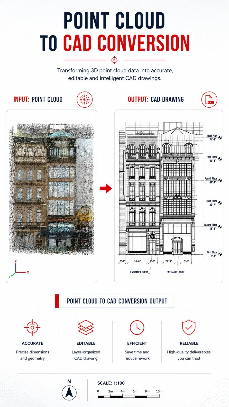
Scan & Point Cloud to CAD Conversion Services

Scan & Point Cloud to CAD Conversion Services

Turn Reality Capture Into Editable CAD

Convert LiDAR laser scan and point cloud data into editable CAD drawings or coordinated Revit BIM models at LOD 100 to 500. Your reality-capture, design, and FM teams stay focused on scan strategy, coordination, and renovation planning, not manual model creation. Direct employees only. ISO-certified.

1,500+

Files converted to CAD weekly

5,000+

Jobs completed monthly

400+

Clients served in the last 3 years

350+

Engineers

Scan & Point Cloud to CAD Conversion Services Scan & Point Cloud to CAD Conversion Services
Quality, Measured

Track Record in Numbers *

Numbers architecture firms can hold us to, tracked across every construction documentation project we deliver.

98.5%*

On-time delivery

Drawing sets delivered on the schedule agreed at project kickoff, so your permit submissions and downstream project timelines stay on track.

98%*

Drawing accuracy

Verified against internal QC checklists and applicable code requirements before a set ever reaches your desk.

95%*

First-time client approval

Drawing sets approved by architecture firms on the first review round, with minimal revision cycles needed.

<0.5%*

Revision request rate

Requests for rework after delivery, a reflection of the accuracy built into the drafting process from the start.

Based on internal production and QA data, January to June 2026.
Scan Sources We Convert

Scan Sources We Convert

We handle every common reality-capture source format from major hardware and software providers.

Terrestrial Laser Scan (TLS) formats

  • Leica RCP, PTS, PTX, IMP
  • FARO FLS, FWS
  • Trimble TZF
  • Riegl RIEGL DAT
  • Autodesk ReCap RCS, RCP

Mobile mapping and handheld scan formats

  • GeoSLAM ZEB point clouds
  • Leica BLK2GO point clouds
  • Matterport MPD (partial support)
  • Handheld iPad LiDAR captures (with quality caveats)

Aerial and drone-captured scans

  • Photogrammetric point clouds (Pix4D, Metashape, ContextCapture)
  • LiDAR from UAV surveys
  • Combined photogrammetry + LiDAR fusion outputs

Legacy and archival scan formats

  • E57 (universal exchange format)
  • LAS / LAZ
  • PLY, XYZ
  • CSV point coordinate exports
Scan to CAD & Point Cloud, What We Deliver

From reality-capture data to coordinated CAD & BIM

Gsource Scan to CAD Conversion - also called Point Cloud to CAD or reality-capture conversion - transforms 3D LiDAR laser scan data into editable CAD drawings or coordinated Revit BIM models. Delivered at the LOD your project requires (100 - 500), standardized to your firm's CAD/Revit template, and coordinated across architectural, structural, and MEP disciplines.

Two output paths - chosen at engagement start based on downstream use case
2D

CAD deliverables

Floor plans Sections Elevations DWG DXF PDF/A
3D

BIM deliverables

Federated Revit models Architectural Structural MEP RVT IFC NWC
Common enterprise use cases we handle
Documenting existing building conditions for renovation and retrofit projects
Converting scanned facility data into BIM models for FM integration
Creating as-built drawings from field-verified reality capture data
Supporting seismic retrofit, MEP upgrade, and life-safety renovation projects
Establishing accurate baselines for capital improvement planning
Preserving heritage or historical building documentation

Delivered at production scale: 1,000+ BIM models delivered monthly by a bench of 50+ dedicated BIM specialists, at 98% conversion accuracy.

1.2M+ sf
Documented from scan across active engagements
98%
Conversion accuracy, delivered at enterprise scale
i

A note on terminology: "Scan to CAD" and "Point Cloud to CAD" are the same service. Looking for 2D document scanning conversion instead - paper drawings scanned to PDF or TIFF, then converted to CAD? See our Paper to CAD Conversion Services page. This page covers 3D laser scan and point cloud work only.

Why Gsource

Why Enterprise Firms Choose Gsource for Scan to CAD

Reality-Capture Specialists on the Bench

Our senior scan-to-CAD team has decades of combined experience across TLS, mobile mapping, aerial LiDAR, and photogrammetry workflows. We work with the actual point cloud data, not just proxy exports.

Both 2D and 3D Output Paths, Under One Contract

Whether you need editable CAD floor plans or a federated Revit BIM model, both delivery paths live under one engagement. Change scope mid-program without switching vendors.

Standards-Aligned Output

Deliverables in your firm's CAD/Revit template, layer conventions, and BIM naming standards. LOD targets set at engagement start, held throughout the program.

ISO 27001 File Handling, Large Point Cloud Datasets

Point cloud files often exceed 100 GB. Secure large-file transfer, ISO 27001-controlled storage, NDA on every engagement. Direct-employee model, no subcontractors.

Testimonials

What Enterprise Reality-Capture Leaders Say

1.2M sf of hospital documentation across 14 campuses. The point cloud data was messy, mixed scanners, some walk-through captures, and Gsource cleaned it up to Revit deliverables at the LOD we needed.

Director of CAD/BIM Standards
National Healthcare System, US Southwest

22,000 drawings across 180 buildings, delivered to our Archibus template with 95% first-time approval. That's the level of consistency we needed. Our internal team couldn't have done this in less than 4 years.

VP of Engineering
Fortune 500 Industrial Manufacturer, US Midwest

Clients are anonymized under NDA.

Our Scan to CAD Workflow

1

Scan Data Assessment & Standards Onboarding

Review your scan data (TLS, mobile mapping, aerial, or mixed). Confirm registration quality, coverage, and coordinate system. Map your CAD/Revit template, LOD target, and BIM naming standards. Sign NDA and confirm IP terms.

2

Point Cloud Registration & Cleanup

If raw scan station data provided, register into unified point cloud. Clean noise, remove artifacts, verify coordinate accuracy against control points.

3

Sample Batch Conversion

Deliver a small sample area (single floor, single zone) for your team to validate against your standards before full-scale production.

4

Full-Scale Conversion Production

Senior-led production of 2D CAD or 3D BIM deliverables. Weekly progress reviews. Multi-discipline coordination if federated BIM output.

5

QA, Coordination & Delivery

ISO 9001 quality checks against your standards. Multi-discipline clash detection if BIM output. Native format delivery (DWG, RVT, IFC, NWC as needed) with source point cloud, registration report, and QA log.

Frequently Asked Questions

Scan to CAD conversion is the process of transforming 3D laser scan data (point cloud files from LiDAR scanners) into editable CAD drawings or coordinated BIM models. Also called Point Cloud to CAD or reality capture conversion.

They are the same service. "Scan to CAD" and "Point Cloud to CAD" are used interchangeably in the industry to describe converting laser scan / LiDAR data to editable CAD or BIM output. If you're looking for 2D document scanning conversion (paper drawings → CAD), see our Paper to CAD Conversion page instead.

All major TLS platforms (Leica, FARO, Trimble, Riegl), mobile mapping (GeoSLAM, Leica BLK2GO, iPad LiDAR), aerial/drone LiDAR, and universal exchange formats (E57, LAS, LAZ, PLY, XYZ). We work directly from raw or registered data.

Yes. Both delivery paths, extracted 2D drawings (DWG/DXF/PDF) and federated 3D Revit BIM models (RVT/IFC/NWC), live under one engagement. Choose at engagement start or switch mid-program.

We deliver LOD 100 through LOD 500, per client specification. Standard renovation projects typically use LOD 300–350. FM handoff work often needs LOD 400+. LOD target is set during Step 1 of our workflow and held throughout the program.

Yes. If you have raw scan station data (uncleaned individual station scans), we perform registration into a unified point cloud during Step 2 of our workflow. If you need field scan capture services, we can refer you to trusted survey partners; the actual CAD/BIM conversion work stays with us.

Point cloud files often exceed 100 GB per building. We use secure large-file transfer protocols (client-hosted SFTP, cloud storage with access controls, or physical media transfer under chain-of-custody). ISO 27001-controlled storage on our side.

Depends on building size, LOD target, and BIM scope. A single 50,000 sf floor plate to 2D CAD: 3-4 weeks. Same floor plate to LOD 300 BIM: 6-8 weeks. Multi-building portfolio programs: scoped over 6-18 months with phased delivery.

NDA signed on every engagement before any scan data or building information is shared. ISO 27001 information security controls. Direct-employee model, no subcontractors. IP and deliverables 100% client-owned. Point cloud source files can be destroyed post-delivery on client request.

Ready to Convert Your Scan Data?

We'll scope your scan volume and target output, walk through similar reality-capture programs, and share a vendor onboarding pack within one business day of a mutual NDA.

NDA available on request · ISO 27001 protocols for large-file scan data · $2M E&O insurance · MSA-ready

Typical First-Call Agenda

  • 1Scan scope, building count, sq ft, scan hardware source
  • 2Data state, raw stations, registered, mixed formats
  • 3Output target, 2D CAD, 3D BIM, or both
  • 4LOD requirements and standards template
  • 5Timeline, engagement model, and NDA/MSA setup

(Enter captcha image text in box)

USA (Corporate Address)

UAE

Pune