What Is Land Development Design and Drafting? A Complete Guide


Table of Contents
Introduction
What is Land Development Design?
Key Land Development Design and Drafting Services
Benefits of Professional Land Development Drafting
Step-by-Step Process of Land Development Design
Conclusion
FAQs
Introduction
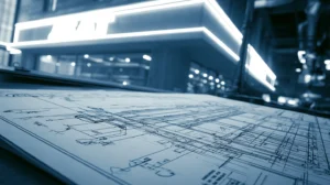
Every successful project begins long before the construction crew comes on site; it starts with vision taking shape on paper. Land development design and drafting turns raw land into a well-planned and buildable reality.
From mapping roads to defining grading levels, this process acts as a blueprint from where everything follows. But it’s not just about drawing but solving complex site challenges, following regulations, and ensuring every detail works smoothly.
What is Land Development Design?
Land development design is a process that turns raw land into buildable space. This design plan ensures how the site is shaped and accessed and covers everything from grading to roads and utilities. A well-developed design ensures the land is not just usable but safe, compliant with regulations, and ready for construction.
It helps to optimize land by aligning design with project goals, budget, and environmental conditions. Effective land development design ensures smooth execution and coordination between stakeholders. Also it creates a roadmap that supports efficient and sustainable project delivery.
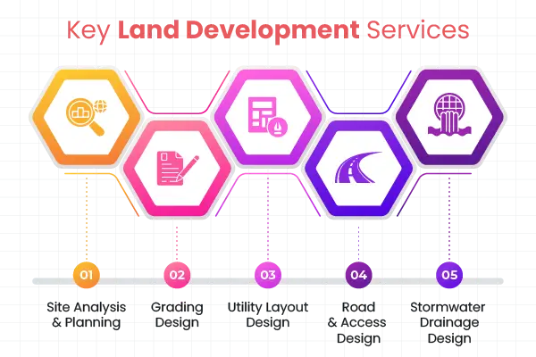
Key Land Development Design and Drafting Services
Explore the core services that ensure the project is well-planned, coordinated, and ready for execution.
-
Site Analysis and Planning
This is an important step where site development drawings is carefully studied for soil condition, topography, and existing constraints. It helps to identify how a site can be better utilized, as a strong plan ensures fewer surprises later in the project.
-
Grading Design
Grading design helps us to know how the land will be shaped to support construction and proper drainage. This balance ensures that the site remains stable and functional. Well-planned grading prevents water issues and reduces costly rework.
-
Utility Layout Design
Utility layouts plan the routing of water, Stormwater, and sewer systems across the site. Proper coordination keeps services running smoothly and avoids conflicts, which is essential for smooth operation and long-term sustainability.
-
Road and Access Design
Road and access design helps draft driveways, internal roads, and access points to ensure safe and efficient movement. It involves traffic flow, connectivity, and site usability, which improve both functionality and user experience.
-
Stormwater Drainage Design
Stormwater design helps to manage rainwater runoffs to prevent flooding and erosion. It includes retention areas, a drainage system, and compliance with regulations. Effective design protects both the site and the surrounding environment.
Benefits of Professional Land Development Drafting
Professional land development drafting ensures that every design is translated into clear, accurate, and construction-ready drawings. Here are various benefits of professional land development drafting.
-
Improved Accuracy and Precision
Professional land development CAD drafting ensures every detail is precise, clearly defined, and technically correct. This reduces the chance of error during construction, as accurate drawings lead to smooth execution on site.
-
Faster Project Approvals
The well-prepared drawings must meet the local standards, as they are easy to approve. This also helps to avoid back-and-forth revision with authorities and speed up the overall project timeline.
-
Better Coordination Across Teams
Detailed drafting aligns with civil, architectural, and utility design. This also minimizes clashes and miscommunication between teams, resulting in more efficient project collaboration.
-
Reduced Rework and Cost
Clear and precise drawings help to avoid mistakes on site. This reduces rework and material wastage, which ultimately helps to keep the project within budget. It also improves overall resource planning and utilization.
-
Time Efficiency
Professional drafting streamlines design to ensure the team has the right information at the right time. This helps the project stay on schedule, which reduces bottlenecks and delays; as a result, project milestones can be achieved consistently.
Step-by-Step Process of Land Development Design
Having a well-defined land development design process ensures that every stage is handled systematically and efficiently.

-
Site Analysis and Data Collection
This is a critical step for a land development project. It involves site topography, existing utilities, soil conditions, and environmental factors. Accurate data helps to identify issues early and ensure informed decision-making.
-
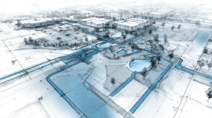
Land Planning and Design
Now the project viability is evaluated based on budget, zoning regulations, and site limitations. Planners assess whether land can support intended development, which helps to avoid risk and ensure project alignment with legal and financial requirements.
-
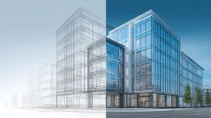
Concept Design Development
Initial ideas are now translated into rough layouts showing plots, roads, utilities, and open spaces. This focus is to optimize land while meeting clients’ and regulatory needs. It provides clear visual direction before starting with a detailed design.
-
Detailed Design and Engineering
Then design development turns into precise technical design, which includes drainage, grading, and utility systems. Engineers ensure all elements work together efficiently and comply with standards, which turn ideas into practical solutions.
-
Drafting and Documentation
All designs are converted into detailed drawings like utility layouts, site plans, and road networks. These documents guide contractors and stakeholders during construction with clear and accurate drafting, which reduces errors on-site.
-
Approval and Permitting
The finalized drawings are submitted to local authorities for approval. Compliance with zoning laws, building codes, and environmental guidelines speeds up the approval process and prevents delays.
-
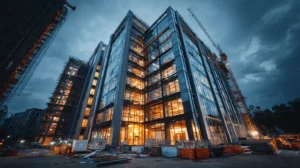
Construction-Ready Design Delivery
Once approved, the final set of drawings is prepared for execution on site. These documents include important details from contractors and a well-prepared design package to ensure efficient construction and project delivery.
Common Challenges in Land Development Projects
The following are the common challenges that land drafters face in complex land development projects:
-
Inaccurate Site Data
Land development heavily depends on survey data, and any error can affect the entire design. Missing utilities, incorrect topography, or outdated information led to incorrect planning.
-
Frequent Design Changes and Revisions
Client requirements, regulatory input, and site conditions may change during the project. These frequent changes in disrupting timelines are major challenges, impacting cost, coordination, and overall project flow.
-
Coordination Issues Between Disciplines
Multiple teams, like civil, architectural, and utility work, constantly work on the project. Without proper coordination, design can clash and cause conflicts on-site. These issues lead to delays, rework, and increased project complexity.
-
Regulatory and Compliance Complexity
Each region has different zoning laws, environmental regulations, and approvals. Ensuring that designs meet all requirements can be complex and time-consuming. Non-compliance results in project delays or rejection of plans.
-
Poor Drainage and Stormwater Management
Improper planning of a drainage system led to flooding, water accumulation, or soil erosion. These issues not just affect site usability but also create long-term maintenance problems.
Conclusion
Land development design is a crucial aspect of planning, research, and expert guidance throughout every phase of your project. Understanding proper permits and zoning regulations and conducting environmental due diligence to protect your investment from costly mistakes.
Partnering with skilled civil engineers and environmental consultants to ensure your civil land development project meets all regulatory requirements while maximizing development potential. These professionals identify potential issues early and create solutions to keep the project on track.
FAQs
Why is professional drafting critical in land development projects?
Without precise drafting, even small errors lead to costly delays and rework. Professional services offered by Gsource ensure compliance, accuracy, and smooth project execution from start.
How does land development drafting help with approvals?
Well-structured and code-compliant drawings make it easier for authorities to review and approve projects quickly. Gsource ensures designs meet local standards and reduces approval bottlenecks.
What type of drawings are included in land development design?
Land drawings include grading plans, site plans, utility plans, and road networks. These guide contractors, engineers, and approval authorities.
How much does land development cost?
Land development costs vary based on project size, complexity, and location of required infrastructure. Site preparation, utility installation, and permitting fees show major expense categories for most projects.
What challenges can arise without proper drafting?
Without proper drafting, challenges like design clash, inaccurate data, and unclear layout lead to budget overruns, delays, and on-site confusion. High-quality drafting minimizes this risk significantly.
How does outsourcing to Gsource improve project outcomes?
Gsource brings specialized expertise, scalable support, and faster turnaround, which allow teams to focus on core decision-making while ensuring high-quality deliverables.
What makes good land development design future-ready?
The strong and precise designs offer sustainability, scalability, and long-term usability. With experienced partners like Gsource, projects are not built for today but optimized for future growth.
Harshad Marne is a passionate civil engineering professional with a deep interest in 3D modeling, design, and land surveying. Proficient in tools like Civil 3D, Revit, ArcGIS, and OpenRoad, he enjoys creating detailed site plans, grading models, and digital terrain models (DTMs) to visualize and analyze infrastructure projects. Beyond the desk, Harshad finds inspiration in nature and iconic civil engineering marvels, exploring landscapes, bridges, dams, and geological formations firsthand.
Read More