Need High-Accuracy Photogrammetry Maps?
Talk to our processing experts

Transforming Photos into Precision Spatial Data
At Gsource, we convert your drone images, aerial photographs, and site captures into precise, engineering-grade photogrammetry outputs, helping surveyors, planners, engineers, environmental teams, and construction professionals make informed, data-backed decisions. With 16+ years of AEC expertise, a 350+ specialist team, ISO-certified quality processes, and a proven 99% client satisfaction rate, we deliver high-accuracy 2D and 3D mapping products globally, tailored to your project’s technical and regulatory standards.
 9001:2015
 27001-2022
 19650-1:2018
 14001:2015
 45001:2018
30–50% faster processing of drone imagery, aerial data and inspection photos
High-accuracy DEMs, DSMs, orthophotos and point clouds with <3% variance
Advanced 3D reconstruction workflows for terrain, structures & infrastructure assets
100% compliance with survey standards, engineering guidelines and GIS requirements
Up to 40% cost savings through optimized data processing and reduced field rework
Seamless support for surveying, planning, engineering and environmental workflows
High-accuracy Digital Terrain and Surface Models generated from processed imagery to support engineering, planning, and analysis.
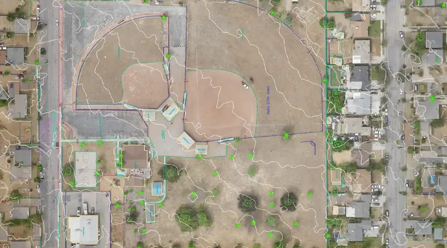
Clean, survey-ready 2D linework extracted from aerial images for mapping utilities, features, boundaries, and structures.
Transform photogrammetry outputs into precise CAD formats, enabling seamless integration with engineering, drafting, and design workflows.
Comprehensive topographic maps derived from aerial data showing elevations, breaklines, features, and ground characteristics accurately.
Carefully curated manual contour lines refined by experts for improved accuracy in complex or vegetation-dense sites.
Classify dense point clouds into ground, vegetation, buildings, and utilities for advanced analysis and modeling workflows.
Correct image distortions, align projections, and ensure accurate georeferencing for consistent mapping and GIS compatibility.
Convert dense point clouds to lighter, optimized datasets without losing essential terrain or feature information.
Add precise labels, feature tags, and annotations to maps and models for easy interpretation and project documentation.
Talk to our processing experts
Multi-level QC for error-free as-built drawings.
Skilled professionals with deep industry experience.
Confidentiality maintained with strict protocols.
Precision and accuracy delivered on tight schedules.
High-quality services without breaking your budget.
Aligned with ISO 9001 and ISO 27001 for consistent quality.
Single point of contact with real-time updates throughout the project.
Clean, organized files with quick help for any updates after delivery.
Get expert support to streamline your next project.

Free Initial Consultation - No Commitment Required

Secure and Confidential Project Information

16+ Years of AEC Expertise

300+ Drawing Deliverables Daily

Industry Standards Compliance Guaranteed
To begin your project, Gsource requires UAV or drone images, GCP coordinates, camera metadata, site notes, and any existing survey benchmarks. Additional inputs like LiDAR data or control points may further enhance accuracy.
The timeline depends on ground coverage, number of images, resolution, terrain complexity, and required deliverables. Gsource provides a clear timeline after reviewing your dataset and project specifications.
You can expect orthophotos, Digital Surface Models (DSM), Digital Terrain Models (DTM), classified point clouds, CAD linework, contours, and GIS-ready datasets based on your scope.
With standardized workflows and advanced photogrammetry software, Gsource achieves sub-inch to survey-grade accuracy when supported by high-quality imagery and proper ground control.
Yes. We support data from all major drones and sensors, including RGB, multispectral, oblique, and high-resolution survey cameras.
Absolutely. Gsource provides automated and manual point cloud classification, noise removal, vegetation filtering, and structural identification for engineering and GIS workflows.
Yes. We provide full CAD conversions, feature extraction, 2D/3D linework creation, and BIM-ready models for engineering and construction teams.
Our ISO-certified workflows include multi-stage QA checks, projection validation, elevation accuracy tests, and deliverable reviews by senior photogrammetry specialists.
(Enter captcha image text in box)