Confused by Complex Site Conditions?
Get clear, accurate boundary and topo survey drafts- fast.

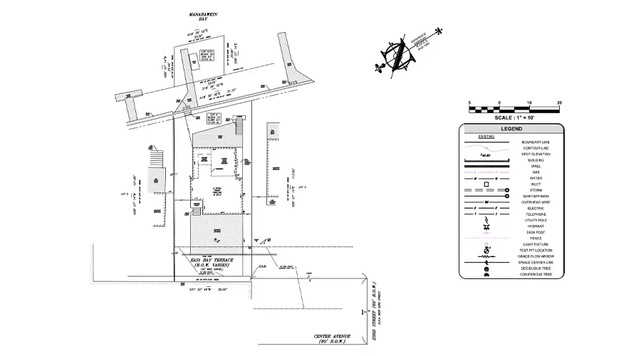
Precise Boundary and Topographical Survey Drafting
At Gsource, we transform your field measurements, survey data, and site notes into precise, approval-ready Boundary and Topographic (Topo) survey drafts that support land development, design, engineering, and property transactions. With 16+ years of global AEC expertise, a 350+ multidisciplinary team, ISO-certified workflows, and a 99% client satisfaction rate, we deliver end-to-end survey drafting solutions globally that ensure clarity, accuracy, and complete compliance with project standards.
 9001:2015
 27001-2022
 19650-1:2018
 14001:2015
 45001:2018
30% faster delivery of detailed boundary and topo survey drafts
<2% variance in elevations, contours, boundary lines, and site features
24/7 collaboration with experienced survey drafting specialists
100% adherence to survey standards, municipal guidelines, and project specifications
Up to 35% cost savings through accurate documentation and reduced rework
Comprehensive boundary maps outlining exact property limits, adjoining parcels, and legal descriptions for accurate land documentation.

Precise depiction of property lines to support ownership clarity, dispute resolution, and legal land verification.
Clear identification of encroachments, easements, and restrictions affecting land use, development potential, and compliance.
Accurate survey drafts that guide planning, permitting, zoning approvals, and smooth progression of land development projects.
High-accuracy topo maps showing terrain, contours, and elevations essential for engineering, grading, and construction planning.
Detailed elevation data and contour mapping that help assess slopes, drainage, and site feasibility effectively.
Precise drafting of structures, pavements, utilities, and improvements to support engineering design and site planning.
Representation of trees, water bodies, vegetation, and terrain characteristics for environmental assessment and project planning.
Reliable boundary and topo data enabling architects and engineers to create accurate, compliant, and constructible design plans.
Get clear, accurate boundary and topo survey drafts- fast.
Multi-level QC for error-free as-built drawings.
Skilled professionals with deep industry experience.
Confidentiality maintained with strict protocols.
Precision and accuracy delivered on tight schedules.
High-quality services without breaking your budget.
Aligned with ISO 9001 and ISO 27001 for consistent quality.
Single point of contact with real-time updates throughout the project.
Clean, organized files with quick help for any updates after delivery.
Get expert support to streamline your next project.

Free Initial Consultation - No Commitment Required

Secure and Confidential Project Information

16+ Years of AEC Expertise

300+ Drawing Deliverables Daily

Industry Standards Compliance Guaranteed
Project timelines depend on land size, terrain complexity, input file quality, and any required revisions. At Gsource, we review your requirements upfront and provide a clear, accurate timeline before drafting begins.
Providing complete and accurate survey inputs, such as point files, site photos, and deed information, helps Gsource reduce rework, accelerate production, and optimize your overall project cost.
We typically require survey data, point cloud files (.CSV or .TXT), LiDAR or drone outputs, deed and title documents, site photos, and any custom CAD standards. Additional inputs may be requested based on project scope.
You receive precise AutoCAD files and PDF drawings with complete boundary details, topo contours, elevations, annotations, and all mapped natural and man-made features, ready for planning, engineering, and permitting.
Yes. Gsource offers post-delivery support, including revisions, updates, and drafting changes to ensure your boundary and topo documents remain accurate and usable.
Yes. Gsource provides Boundary and Topographic Survey Drafting for commercial, industrial, multi-parcel, and mixed-use developments, ensuring accuracy across complex site conditions.
Absolutely. Our team specializes in converting drone imagery and LiDAR datasets into detailed contour mapping, surface models, and boundary drawings with high precision.
We follow multi-level QA checks, industry drafting standards, and precise CAD workflows, ensuring <2% variance across boundaries, contours, elevations, and site features.
Yes. Gsource acts as an extended drafting team for surveyors, civil engineering firms, and developers, handling recurring boundary, topo, and mapping projects with quick turnaround.
Yes. We fully adapt drafting styles, layers, symbols, and annotations to your county standards, CAD templates, or specific municipal requirements for faster approvals.
(Enter captcha image text in box)