How LiDAR Point Cloud Processing Transforms Raw Scan Data into Accurate Maps


Table of Contents
Overview of LiDAR Point Cloud Processing
Transforming Raw Scan Data into Accurate Maps with LiDAR Data Processing
Why Does LiDAR Map Accuracy Matter?
Challenges in LiDAR Point Cloud Processing
Conclusion
FAQs
At first glance, LiDAR data looks like a chaotic cloud of dots with millions of points floating with no clear shape. But inside that raw scan is a highly accurate picture of real land. With LiDAR point cloud processing, scattered points are properly cleaned, classified, and refined, and exact replicas of buildings, grounds, and terrain are found.
LiDAR transforms the chaos into clarity and finally emerges not just as a map but as a representation of reality on which designers and engineers can rely on. From planning to final construction, LiDAR data offer fewer errors, smarter decisions, and maps that truly reflect the world as it exists.
Overview of LiDAR Point Cloud Processing
LiDAR point cloud processing helps in cleaning, capturing, and analyzing the dense 3D data from laser scans to create accurate models of the environment. This technology powers applications such as urban planning, autonomous vehicles, and construction surveying by transforming raw point clouds into actionable insights.
Key Benefits of LiDAR Point Cloud Processing
LiDAR point cloud processing is your key to transforming raw data into accurate and usable information. Explore more benefits of LiDAR point cloud processing for your projects.
-
High-Precision Terrain and Elevation Data
LiDAR point cloud processing offers highly accurate elevation and surface models. It captures terrain details more accurately compared to traditional surveying methods.
-
Faster Data Processing and Project Turnaround
Automated point cloud classification and filtering reduce manual effort, allowing for the quick processing of a large volume of data without compromising quality. This helps the team meet deadlines and accelerate overall project delivery.
-
Improved Feature Extraction and Classification
Processed LiDAR data allows for accurate identification of vegetation, ground, buildings, and utilities. Clear classification ensures clean datasets for the design and analysis team.
-
Cost Efficiency for Large-Scale Projects
LiDAR processing reduces the need for extensive field surveys. It lowers labor costs while efficiently covering vast and complex areas. Point cloud processing makes it a cost-effective solution for infrastructure and land development projects.
-
Better Decision Making with Detailed 3D Visualization
LiDAR point clouds offer detailed 3D representations of existing conditions. Stakeholders can clearly visualize terrain and structures before construction, improving understanding, coordination, and informed decision-making.
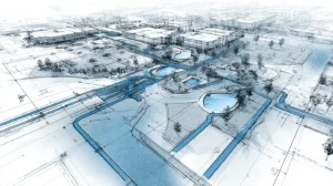
Transforming Raw Scan Data into Accurate Maps with LiDAR Data Processing
![]()
LiDAR survey drafting captures a high amount of raw data, but this data cannot be processed for mapping or design. With structured processing workflow points, clouds are refined, organized, and converted into accurate, map-ready outputs.
Here are step-by-step details on how LiDAR point cloud processing transforms raw scan data into accurate maps.
-
Data Collection and Import
LiDAR data is collected using terrestrial, airborne, or mobile scanning systems based on project requirements. Once collected, raw scan data is imported into processing software and checked for coordinate system accuracy, coverage, and data integrity before processing begins.
-
Registration and Georeferencing
Multiple LiDAR scans are aligned and combined into a single unified dataset. Georeferencing ensures the point cloud matches real-world coordinates using GPS data and ground control points, forming the foundation for spatial accuracy.
-
Noise Filtering and Data Cleaning
Raw data often includes unwanted points caused by birds, dust, moving vehicles, or reflective surfaces. These noise points are filtered out to improve data clarity while preserving critical terrain and feature information.
-
Point Cloud Classification
Each LiDAR point is assigned to a specific category such as vegetation, ground, buildings, roads, or utilities. Proper classification structures the dataset and enables accurate extraction of terrain and man-made features through advanced point cloud classification.
-
Ground Extraction and Terrain Modeling
Non-ground features such as structures and trees are removed to isolate bare-earth data. This cleaned ground dataset is used to create Digital Terrain Models (DTM) and elevation surfaces required for topographic mapping.
-
Feature Extraction and Terrain Modeling
Important features like breaklines, contours, road edges, and building outlines are extracted from the classified point cloud. These features are converted into CAD and GIS-compatible linework for design, planning, and analysis.
-
Accuracy Validation and Quality Control
The processed data is thoroughly checked for vertical and horizontal accuracy against known survey control points. Quality control ensures final maps meet project specifications, client expectations, and regulatory standards.
-
Final Map Generation and Deliverables
The validated data is transformed into final outputs like geospatial mapping outputs, as contour drawings, topographic maps, GIS layers, and 3D surfaces. These deliverables provide reliable information for engineering, construction, and land development projects.
Raw scans. Costly inaccuracies. Unverified coordinates.
Turn LiDAR point processing into survey-grade, decision-ready maps.
Why Does LiDAR Map Accuracy Matter?
LiDAR maps are the basis for critical design and planning design. When accuracy is high, the team can trust the data and avoid costly mistakes or rework later in the project.
-
Ensure Reliable Design and Engineering Decisions
Accurate LiDAR maps provide a strong foundation for design and planning. Even small elevation errors can lead to major design flaws. High accuracy ensures engineers base their decisions on real-world conditions rather than assumptions.
-
Reduce Costly Errors and Rework
Inaccurate LiDAR data can result in incorrect grading, alignment, and utility placement. This may lead to redesigns, delays, and added costs. Precise mapping helps avoid downstream corrections and project overruns.
-
Support Precise Earthwork and Volume Calculation
LiDAR accuracy directly impacts cut-and-fill and volume estimates. Reliable data ensures quantities are calculated correctly, improving bidding accuracy, budgeting, and construction planning.
-
Enable Compliance with Regulatory and Survey Standards
Many projects must meet strict accuracy and tolerance standards. Reliable LiDAR data ensures alignment with local and international guidelines, minimizing compliance risks and approval delays.
-
Improve Integration with CAD, GIS, and BIM Workflows
Accurate LiDAR maps integrate smoothly into design workflows. Clean and precise data reduce the need for manual adjustments, leading to faster modeling and more consistent project outcomes.
Challenges in LiDAR Point Cloud Processing
LiDAR point cloud processing faces challenges due to high data complexity and volume. Here are challenges that drafters may face in LiDAR point cloud processing:
-
High Data Volume
LiDAR point clouds contain millions to billions of points, placing heavy demands on transmission, storage, and computational resources. Standard tools often struggle to manage such large datasets without high-performance hardware.
-
Lack of Structure
Unlike images, point clouds do not have inherent order, making segmentation and feature extraction more complex. Boundaries between objects and ground surfaces can be unclear, especially for distant or thin features.
-
Noise and Incompleteness
Environmental factors such as weather conditions introduce noise and data gaps. Processing algorithms must remove noise and fill missing areas carefully to avoid compromising accuracy.
-
Real-Time Demands
In LiDAR processing applications such as autonomous driving, milliseconds matter for safety-critical decisions. Balancing speed and precision remains a major technical challenge.
-
Interoperability Issues
LiDAR sensors and software use various formats such as LAZ, LAS, and PLY, making seamless data sharing across platforms difficult. Converting between formats can lead to data loss or workflow inefficiencies.
Conclusion
LiDAR point cloud processing turns scattered laser points into clear and credible maps. By cleaning, classifying, and validating the raw scan data, it reveals the actual shape of the land and built environment. The result is accurate mapping, which supports smart decisions, smooth workflow, and project outcomes that are led by confidence.
FAQs
What is LiDAR Data Processing?
LiDAR data processing helps to analyze and interpret raw 3D point cloud data into usable and accurate spatial information. This helps in cleaning, classifying, and analyzing point cloud data to create terrain models, maps, and 3D representations.
How do weather conditions affect the LiDAR accuracy?
Rain, fog, dust, and direct sunlight can scatter or distort laser pulses, which reduces the accuracy of returns.
Can cloud data improve quality control in manufacturing?
Yes, point cloud data helps to detect defects, measure parts, and compare products to digital models. This led to fast inspection and high product quality.
What are some applications for LiDAR data processing?
LiDAR data processing has a wide range of applications, like topographic mapping, urban planning, and flood modeling. This is also used in industries like construction, forestry, and transportation.
How does point classification improve map accuracy?
The classification separates points into ground, vegetation, building, and other features. This helps to create a precise terrain model and feature map, as accurate classification ensures the right representation of real-world conditions.
How are elevation models created from point clouds?
Ground points are extracted from point cloud data, as these points are used to generate Digital Elevation Models (DEMs) or Digital Terrain Models (DTMs). Accurate elevation models are important for design and analysis.
How does processed LiDAR data integrate with CAD and GIS tools?
Processed point clouds are converted into compatible formats. These can easily be imported into the CAD, GIS, and BIM platforms, as these support smooth drafting, modeling, and spatial analysis.
Can LiDAR point cloud processing reduce field survey effort?
Yes, processed LiDAR data reduces the need for repeated site visits. It captures the detailed terrain and features remotely, which saves time, cost, and field labor.
Sandeep Dhage is the Associate Director of Engineering at Gsource Technologies, leading innovative surveying and data processing solutions. With expertise in Boundary and Topographic Surveys, Commercial Boundary Surveys, ALTA/NSPS Survey Drafting, and advanced techniques like Photogrammetry, LiDAR, and Drone Data, Sandeep excels at delivering comprehensive, high-quality solutions. His dedication to understanding project challenges allows him to craft practical, industry-standard, and effective solutions with precision and efficiency. In his free time, Sandeep enjoys experimenting with drone technology, capturing stunning landscapes, and diving into complex data analysis.
Read More